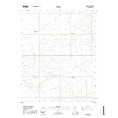
2020 Map of Snyder Lake
USGS Topo · Published 2020About this map
Cinder Mtn rises above a high plains landscape defined by the drainage networks of the Canadian River watershed. This corner of Union County is characterized by the winding paths of Perico Cr and Carrizo Cr, which carve through the volcanic and sedimentary geology typical of the northeastern New Mexico highlands. The topography is predominantly open range, marked by the intersection of townships T26N and T25N. A network of rural routes, including Atchely Rd and Wiley Rd, provides access to these isolated pastures and draws. Smaller watercourses like Cedar Cr emphasize the seasonal hydrology of the region. This 2020 update by the U.S. Geological Survey details the contemporary land management boundaries and road access through a landscape largely shaped by ranching and natural erosion.
Find a feature on this map
16 named features on this map. Tap any name to fly to it.
Don’t see what you’re looking for? This feature index may not catch every label — zoom into the map to look around manually.
Map Details
Editions of this 2020 Snyder Lake Map
This is the sole edition of this map. No revisions or reprints were ever made.
Other maps of this area

1954 · Dalhart
USGS Topo · 1:250,000

1958 · Dalhart
USGS Topo · 1:250,000

1962 · Dalhart
USGS Topo · 1:250,000

1966 · Black Canyon
USGS Topo · 1:24,000

1966 · Tate School
USGS Topo · 1:24,000

1972 · Mount Dora
USGS Topo · 1:24,000

1973 · Grenville SW
USGS Topo · 1:24,000

1973 · Snyder Lake
USGS Topo · 1:24,000

1973 · Tripod Mountain
USGS Topo · 1:24,000
1973 · Goat Canyon
USGS Topo · 1:24,000