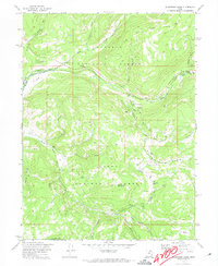
1972 Map of Soapstone Basin
USGS Topo · Published 1974About this map
Uinta National Forest lands dominate this high-elevation landscape, where the headwaters of the Provo River systems converge. Managed by the U.S. Forest Service at the time of this 1970s survey, the area reflects a mid-century focus on public recreation and resource monitoring. The concentration of developed sites like Camp Roger, the Soapstone Guard Sta, and the Shady Dell Campground suggests a well-established seasonal use pattern. Water management and conservation are central to the map's details, evidenced by the Gaging Sta on the North Fork Provo River and the Water Tank near the guard station. Topographical features like Soapstone Mountain and Silver Meadow define the high basins, while various pack trails and jeep trails indicate the methods of access to the more remote drainages including Lambert Hollow and Nobletts Creek.
Find a feature on this map
37 named features on this map. Tap any name to fly to it.
Don’t see what you’re looking for? This feature index may not catch every label — zoom into the map to look around manually.
Map Details
Editions of this 1972 Soapstone Basin Map
2 editions found
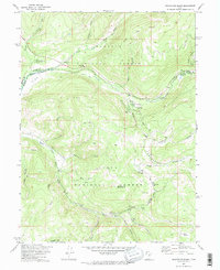
Other maps of this area

1885 · Salt Lake
USGS Topo · 1:250,000

1885 · Uinta
USGS Topo · 1:250,000

1900 · Coalville
USGS Topo · 1:125,000

1901 · Hayden Peak
USGS Topo · 1:125,000

1903 · Hayden Peak
USGS Topo · 1:125,000

1903 · Coalville
USGS Topo · 1:125,000

1907 · Strawberry Valley
USGS Topo · 1:125,000

1909 · Strawberry Valley
USGS Topo · 1:125,000

1954 · Salt Lake City
USGS Topo · 1:250,000

1958 · Salt Lake City
USGS Topo · 1:250,000