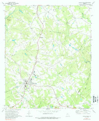
1971 Map of Social Circle
USGS Topo · Published 1988About this map
The town of Social Circle serves as the central hub of this Georgia landscape, situated at the junction of Georgia 11 and the Georgia railroad line. The map captures a transition from the structured residential blocks of the town to the surrounding agricultural and timbered lands. West of the town center, Circle View Cem and the nearby Filtration Plant mark the edge of the community, while the Alcovy River and its tributary Naked Creek define the western drainage towards Alcovy Mtn.
Find a feature on this map
41 named features on this map. Tap any name to fly to it.
Don’t see what you’re looking for? This feature index may not catch every label — zoom into the map to look around manually.
Map Details
Editions of this 1971 Social Circle Map
3 editions found
Other maps of this area

1896 · Monroe
USGS Topo · 1:125,000

1953 · Athens
USGS Topo · 1:250,000

1958 · Athens
USGS Topo · 1:250,000

1959 · Athens
USGS Topo · 1:250,000

1963 · Athens
USGS Topo · 1:250,000

1964 · Between
USGS Topo · 1:24,000

1964 · High Shoals
USGS Topo · 1:24,000

1964 · Monroe
USGS Topo · 1:24,000

1964 · Covington
USGS Topo · 1:24,000
1964 · Jersey
USGS Topo · 1:24,000