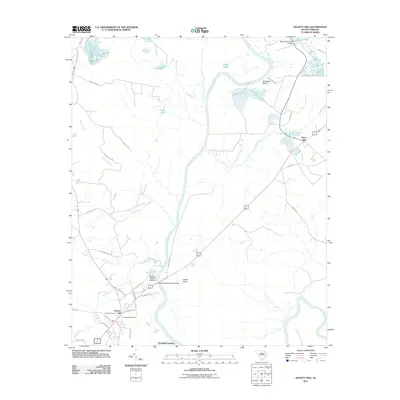
2011 Map of Society Hill
USGS Topo · Published 2011About this map
The Society Hill settlement sits on the western banks of the Great Pee Dee River in this 2011 survey, reflecting a landscape defined by water and history. This riverfront area, including Plumfield Landing and the Welsh Neck district, shows a deep connection to its agricultural and milling past. Small industrial features like Klopman Mill Pond and Mathesons Millpond dot the tributaries of the Great Pee Dee, while the Welch Neck Memorial Bridge provides a primary crossing point near the historic town center.
Find a feature on this map
46 named features on this map. Tap any name to fly to it.
Don’t see what you’re looking for? This feature index may not catch every label — zoom into the map to look around manually.
Map Details
Editions of this 2011 Society Hill Map
This is the sole edition of this map. No revisions or reprints were ever made.
Other maps of this area

1942 · Rockingham
USGS Topo · 1:125,000

1943 · Gum Swamp
USGS Topo · 1:62,500

1953 · Florence
USGS Topo · 1:250,000

1954 · Florence
USGS Topo · 1:250,000

1963 · Dovesville
USGS Topo · 1:24,000

1963 · Mont Clare
USGS Topo · 1:24,000
1971 · Wallace
USGS Topo · 1:24,000
1971 · Cheraw
USGS Topo · 1:24,000

1971 · Society Hill
USGS Topo · 1:24,000
1972 · Cash
USGS Topo · 1:24,000