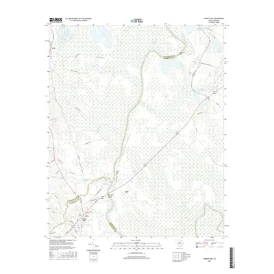
2017 Map of Society Hill
USGS Topo · Published 2017About this map
The Great Pee Dee River winds through this landscape on the border of Chesterfield, Darlington, and Marlboro counties, shaping the region's agricultural and historical character. At the heart of the area, Society Hill serves as a focal point for local history, featuring prominent landmarks such as Trinity Ch and the Welsh Neck Cem. The map documents a territory defined by its water features, from the expansive Goose Marsh to smaller bodies like Klopman Mill Pond and Mathesons Millpond. Genealogists and historians will find significant markers of the past, including Colonel Kolbs Tomb and the Welch Neck Memorial Bridge crossing near the settlement of Welsh Neck. The network of rural roads, including Colonel Cash Rd and Becker Rd, connects the scattered communities of Cash and Gardners Bluff across the fertile Pee Dee lowlands.
Find a feature on this map
55 named features on this map. Tap any name to fly to it.
Don’t see what you’re looking for? This feature index may not catch every label — zoom into the map to look around manually.
Map Details
Editions of this 2017 Society Hill Map
This is the sole edition of this map. No revisions or reprints were ever made.
Other maps of this area

1942 · Rockingham
USGS Topo · 1:125,000

1943 · Gum Swamp
USGS Topo · 1:62,500

1953 · Florence
USGS Topo · 1:250,000

1954 · Florence
USGS Topo · 1:250,000

1963 · Dovesville
USGS Topo · 1:24,000

1963 · Mont Clare
USGS Topo · 1:24,000
1971 · Wallace
USGS Topo · 1:24,000
1971 · Cheraw
USGS Topo · 1:24,000

1971 · Society Hill
USGS Topo · 1:24,000
1972 · Cash
USGS Topo · 1:24,000