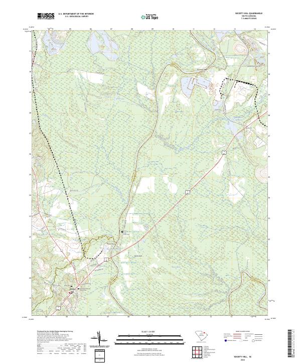
2024 Map of Society Hill
USGS Topo · Published 2024About this map
Society Hill sits at a historic crossroads where the Pee Dee region's river-driven past meets the contemporary landscape. This 2024 data reveals a terrain heavily defined by the meandering Great Pee Dee River, which serves as a natural border for Darlington, Marlboro, and Chesterfield counties. Significant genealogical landmarks are preserved here, including the Welsh Neck Baptist Church Cem and the Colonel Kolbs Tomb Cem near Welsh Neck, marking early settlement sites along the riverbanks. The map illustrates a complex hydrographic network where Gardners Bluff overlooks the water, and former industrial or agricultural sites like Klopman Mill Pond and Mathesons Millpond persist alongside natural features like Goose Marsh. The presence of Sparks Ferry further emphasizes the area's long reliance on river crossings for regional connectivity.
Find a feature on this map
60 named features on this map. Tap any name to fly to it.
Don’t see what you’re looking for? This feature index may not catch every label — zoom into the map to look around manually.
Map Details
Editions of this 2024 Society Hill Map
This is the sole edition of this map. No revisions or reprints were ever made.
Other maps of this area

1942 · Rockingham
USGS Topo · 1:125,000

1943 · Gum Swamp
USGS Topo · 1:62,500

1953 · Florence
USGS Topo · 1:250,000

1954 · Florence
USGS Topo · 1:250,000

1963 · Dovesville
USGS Topo · 1:24,000

1963 · Mont Clare
USGS Topo · 1:24,000
1971 · Wallace
USGS Topo · 1:24,000
1971 · Cheraw
USGS Topo · 1:24,000

1971 · Society Hill
USGS Topo · 1:24,000
1972 · Cash
USGS Topo · 1:24,000