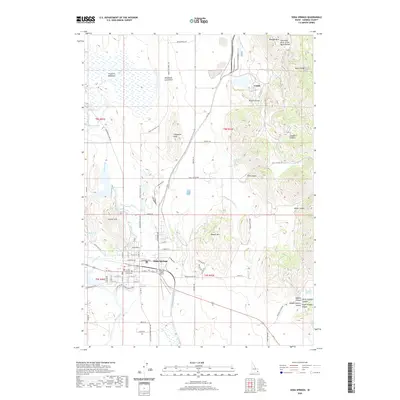
2020 Map of Soda Springs
USGS Topo · Published 2020About this map
Soda Springs serves as the center of activity on this Caribou County landscape, situated where the Bear River meets an intricate network of local irrigation and natural flows. The town's grid is anchored by the Caribou County Courthouse and Stampede Park, while the Allen H Tigert Airport marks the eastern edge of the settlement. To the north, the industrial character of Conda stands in contrast to the geological features of the Blackfoot Lava Field and the elevations of Woodall Mtn. This area is defined by its hydrography, from the geothermal activity at Mammoth Spring and Hooper Spring to the significant geographic marker of the Columbia River Great Basin Divide crossing the Aspen Range. The map captures a sophisticated water management system including the Soda Canal and The Reservoir, essential for the agricultural and municipal needs of this high-altitude basin.
Find a feature on this map
108 named features on this map. Tap any name to fly to it.
Don’t see what you’re looking for? This feature index may not catch every label — zoom into the map to look around manually.
Map Details
Editions of this 2020 Soda Springs Map
This is the sole edition of this map. No revisions or reprints were ever made.
Other maps of this area

1911 · Slug Creek
USGS Topo · 1:62,500

1914 · Henry
USGS Topo · 1:48,000

1915 · Lanes Creek
USGS Topo · 1:62,500

1916 · Henry
USGS Topo · 1:62,500

1948 · Soda Springs
USGS Topo · 1:62,500

1949 · Soda Springs
USGS Topo · 1:62,500

1949 · Johnson Creek
USGS Topo · 1:24,000

1949 · Lower Valley
USGS Topo · 1:24,000

1951 · Lower Valley
USGS Topo · 1:24,000
1951 · Johnson Creek
USGS Topo · 1:24,000