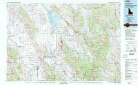
1982 Map of Soda Springs
USGS Topo · Published 1982About this map
Soda Springs serves as the industrial and transport hub for this Idaho-Wyoming borderlands region, where the Union Pacific railroad and US Highway 30 facilitate the movement of goods through the Gem Valley. The landscape is defined by its phosphate mining legacy, clearly visible through the Phosphate Mine operations and Tailings Ponds near the settlement of Conda. To the north, the Blackfoot Reservoir and Chesterfield Reservoir manage water resources against the backdrop of the Caribou Range and Aspen Range. Smaller agricultural and ranching communities like Chesterfield, Bancroft, and Grace dot the valleys between the high ridges of the Webster Range and Gannett Hills. This survey documents a critical period of natural resource extraction and high-country settlement, anchored by the Caribou National Forest and the eastern edge of the Fort Hall Indian Reservation.
Find a feature on this map
87 named features on this map. Tap any name to fly to it.
Don’t see what you’re looking for? This feature index may not catch every label — zoom into the map to look around manually.
Map Details
Editions of this 1982 Soda Springs Map
2 editions found
Other maps of this area

1909 · Montpelier
USGS Topo · 1:125,000

1911 · Montpelier
USGS Topo · 1:125,000

1911 · Slug Creek
USGS Topo · 1:62,500

1914 · Henry
USGS Topo · 1:48,000

1915 · Preston
USGS Topo · 1:96,000

1915 · Freedom
USGS Topo · 1:62,500

1915 · Crow Creek
USGS Topo · 1:62,500

1915 · Lanes Creek
USGS Topo · 1:62,500

1916 · Henry
USGS Topo · 1:62,500

1917 · Portneuf
USGS Topo · 1:62,500