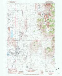
1982 Map of Soda Springs
USGS Topo · Published 1982About this map
Soda Springs serves as the industrial and hydraulic hub of this Idaho landscape, where the Bear River is controlled by the Alexander Reservoir at the western edge of town. The area’s mineral wealth is evident in the sprawling Phosphate Plant and the mining community of Conda to the northeast. Beyond the rail lines of the Union Pacific, the geography is defined by a series of significant thermal and mineral waters, including Hooper Spring, Mammoth Spring, and the unique geological features of Formation Spring and Formation Cave. The eastern portion of the map climbs into the Aspen Range, revealing the site of the Idaho Sulphur Mine and Dewey Sulphur Mine tucked into Sulphur Canyon. This combination of heavy industry, rail transport, and diverse water sources highlights the complex economic and natural history of the Caribou County region.
Find a feature on this map
32 named features on this map. Tap any name to fly to it.
Don’t see what you’re looking for? This feature index may not catch every label — zoom into the map to look around manually.
Map Details
Editions of this 1982 Soda Springs Map
This is the sole edition of this map. No revisions or reprints were ever made.
Other maps of this area

1911 · Slug Creek
USGS Topo · 1:62,500

1914 · Henry
USGS Topo · 1:48,000

1915 · Lanes Creek
USGS Topo · 1:62,500

1916 · Henry
USGS Topo · 1:62,500

1948 · Soda Springs
USGS Topo · 1:62,500

1949 · Soda Springs
USGS Topo · 1:62,500

1949 · Johnson Creek
USGS Topo · 1:24,000

1949 · Lower Valley
USGS Topo · 1:24,000

1951 · Lower Valley
USGS Topo · 1:24,000
1951 · Johnson Creek
USGS Topo · 1:24,000