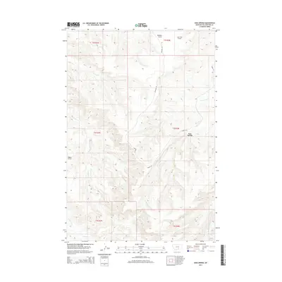
2014 Map of Soda Springs
USGS Topo · Published 2014About this map
Soda Springs serves as the focal point of this Yellowstone County landscape, where the high plains of Montana are deeply etched by a network of drainage coulees and seasonal creeks. The terrain is defined by the sharp relief of the Pryor Creek watershed, including the E Fork Pryor Cr and Birdhead Cr, which carve through the underlying geological strata. This 2014 survey reveals a sparsely populated ranching environment where movement is dictated by the land's contours, connected by rural routes such as Barnes Rd and Vermandel Rd. To the north, the curiously named Badbaby Coulee and Lone Tree Coulee provide significant landmarks for navigation across the open country, illustrating the localized vernacular of the region's geography.
Find a feature on this map
18 named features on this map. Tap any name to fly to it.
Don’t see what you’re looking for? This feature index may not catch every label — zoom into the map to look around manually.
Map Details
Editions of this 2014 Soda Springs Map
This is the sole edition of this map. No revisions or reprints were ever made.
Other maps of this area

1893 · Huntley
USGS Topo · 1:125,000

1954 · Billings
USGS Topo · 1:250,000

1957 · Billings
USGS Topo · 1:250,000

1958 · Billings
USGS Topo · 1:250,000

1967 · Deep Creek
USGS Topo · 1:24,000

1967 · Soda Springs NW
USGS Topo · 1:24,000

1967 · Soda Springs
USGS Topo · 1:24,000
1967 · Chilkoot Coulee
USGS Topo · 1:24,000
1967 · Badbaby Coulee
USGS Topo · 1:24,000
1967 · Vale Creek Ranch
USGS Topo · 1:24,000