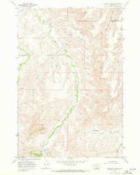
1967 Map of Chilkoot Coulee
USGS Topo · Published 1972About this map
East Fork Pryor Creek meanders through the heart of the Crow Indian Reservation in this late-1960s survey of south-central Montana. The landscape is defined by its drainage systems and high ground, most notably Wild Horse Ridge to the east and the namesake Chilkoot Coulee to the north. While the area is largely characterized by open terrain, the map records specific human imprints such as the Schenk Ranch and a remote Landing Strip near the center of the quadrangle. A county line between Yellowstone and Big Horn counties bisects the northwestern corner. The presence of a Pipeline and a Radio Tower suggests the modern infrastructure threading through this traditional landscape, while numerous waterways like Beauvais Creek and Cottonwood Creek indicate the vital natural arteries of the region.
Find a feature on this map
13 named features on this map. Tap any name to fly to it.
Don’t see what you’re looking for? This feature index may not catch every label — zoom into the map to look around manually.
Map Details
Editions of this 1967 Chilkoot Coulee Map
2 editions found
Other maps of this area

1893 · Huntley
USGS Topo · 1:125,000

1954 · Billings
USGS Topo · 1:250,000

1957 · Billings
USGS Topo · 1:250,000

1958 · Billings
USGS Topo · 1:250,000
1964 · Horse Coulee
USGS Topo · 1:24,000

1967 · Deep Creek SE
USGS Topo · 1:24,000

1967 · Deep Creek
USGS Topo · 1:24,000

1967 · Deep Creek SW
USGS Topo · 1:24,000

1967 · Soda Springs
USGS Topo · 1:24,000
1967 · Vale Creek Ranch
USGS Topo · 1:24,000