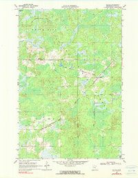
1969 Map of Solana
USGS Topo · Published 1980About this map
White Pine State Forest and Pliny State Forest dominate this Aitkin County landscape, where the dense timberlands are crisscrossed by a network of specialized access routes like the White Pine Truck Trail and Herubin Truck Trail. The settlement of Solana sits as a quiet hub in the eastern portion of the quadrangle, positioned near the Soo Line tracks. This rail infrastructure was central to the region's development, evidenced by the presence of an Old Railroad Grade that speaks to earlier logging or transport corridors now superseded by the modern line.
Find a feature on this map
12 named features on this map. Tap any name to fly to it.
Don’t see what you’re looking for? This feature index may not catch every label — zoom into the map to look around manually.
Map Details
Editions of this 1969 Solana Map
2 editions found
Other maps of this area

1953 · Duluth
USGS Topo · 1:250,000

1958 · Duluth
USGS Topo · 1:250,000

1968 · Kroschel NW
USGS Topo · 1:24,000

1968 · Giese
USGS Topo · 1:24,000

1968 · Mc Grath
USGS Topo · 1:24,000

1969 · Solana
USGS Topo · 1:24,000

1969 · Arthyde
USGS Topo · 1:24,000

1969 · Thor NE
USGS Topo · 1:24,000

1969 · Thor SE
USGS Topo · 1:24,000

1969 · Split Rock Lake
USGS Topo · 1:24,000