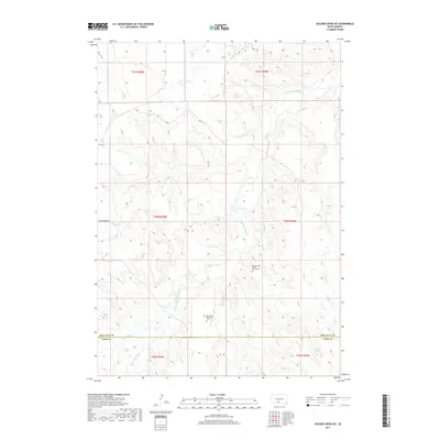
2017 Map of Soldier Creek NE
USGS Topo · Published 2017About this map
The Little White River meanders across this landscape in south-central South Dakota, carving a complex network of drainage basins including Little Oak Cr, Cut Meat Cr, and Dry Cr. This area on the border of Mellette and Todd counties is characterized by high-relief prairie terrain, with few primary roads beyond the established Ring Thunder Rd. Significant sites for local history and genealogy are centered on the Ring Thunder Sacred Heart Cem and the Saint John Episcopal Cem, both situated near the primary watercourses. The mapping of the Public Land Survey System (PLSS) townships, including t40n r30w and t39n r29w, reflects the late-period land divisions in the Antelope Segment.
Find a feature on this map
14 named features on this map. Tap any name to fly to it.
Don’t see what you’re looking for? This feature index may not catch every label — zoom into the map to look around manually.
Map Details
Editions of this 2017 Soldier Creek NE Map
This is the sole edition of this map. No revisions or reprints were ever made.
Other maps of this area

1955 · Martin
USGS Topo · 1:250,000

1958 · Martin
USGS Topo · 1:250,000

1969 · Soldier Creek NE
USGS Topo · 1:24,000

1969 · Soldier Creek
USGS Topo · 1:24,000

1969 · Mission NW
USGS Topo · 1:24,000

1969 · Mission
USGS Topo · 1:24,000

1969 · Soldier Creek NW
USGS Topo · 1:24,000

1969 · Soldier Creek SE
USGS Topo · 1:24,000
1982 · Murdo 3 NW
USGS Topo · 1:25,000

1982 · White River East
USGS Topo · 1:24,000
Featured Places
- Antelope Segment, SD
- Horse Creek Segment, SD
- Ring Thunder Segment, SD
- Soldier Creek Segment, SD
- Todd County, SD