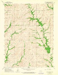
1964 Map of Soldier Creek SE
USGS Topo · Published 1965About this map
The Potawatomi Indian Reservation dominates the southern landscape of this mid-1960s survey, with the Potawatomi Indian Reservation Boundary clearly delineated across the townships of Lincoln, Washington, and Douglas. The terrain is defined by a dense network of drainage, including the winding courses of Little Soldier Creek, South Branch Soldier Creek, and James Creek. This rural section of Jackson County is marked by its community landmarks, such as the Potawatomi Mission Ch and rural education centers like Grand Prairie Sch and Sunnybrook Sch. Local genealogy is anchored by family-named sites including Mitchell Cem and Shipshee Cem, while small-scale land use is indicated by scattered gravel pits. The map reveals a settled agricultural landscape where section lines and unimproved roads follow the ridges between the numerous wooded creek valleys.
Find a feature on this map
17 named features on this map. Tap any name to fly to it.
Don’t see what you’re looking for? This feature index may not catch every label — zoom into the map to look around manually.
Map Details
Editions of this 1964 Soldier Creek SE Map
This is the sole edition of this map. No revisions or reprints were ever made.
Other maps of this area

1889 · Topeka
USGS Topo · 1:125,000

1894 · Topeka
USGS Topo · 1:125,000

1950 · Kansas City
USGS Topo · 1:250,000

1952 · Rossville
USGS Topo · 1:24,000

1952 · Elmont
USGS Topo · 1:24,000

1952 · Grove
USGS Topo · 1:24,000

1954 · Kansas City
USGS Topo · 1:250,000

1956 · Kansas City
USGS Topo · 1:250,000

1960 · Kansas City
USGS Topo · 1:250,000
1960 · Mayetta
USGS Topo · 1:24,000