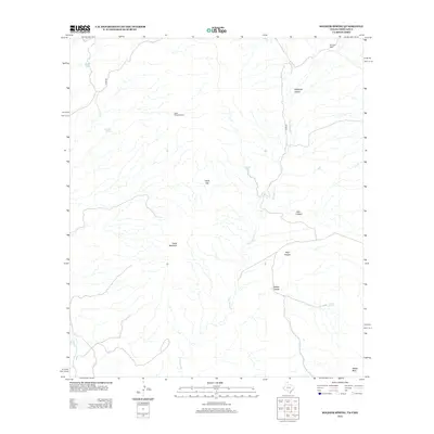
2013 Map of Soldier Spring
USGS Topo · Published 2013About this map
Van Horn Cr carves a central path through this high-desert landscape in Presidio County, defining a region where water sources dictated human settlement and ranching operations. The terrain is marked by significant geological features including Chalk Mountain, Chalk Gap, and the prominent Soldier Mesa in the southeast. Evidence of the cattle ranching era is found at the Ninetysix Camp and the South Chiva Windmill, while isolated water points like Painted Spring, Chalk Tank, and the namesake Soldier Spring provided essential resources in this arid environment. The map details a complex network of canyons, from the northern Ninetysix Canyon to Joho Canyon, Vieja Canyon, and Soldier Canyon. Infrastructure is minimal, represented primarily by Chispa Rd and White Tank, illustrating the remote character of the West Texas borderlands during the early 21st century.
Find a feature on this map
15 named features on this map. Tap any name to fly to it.
Don’t see what you’re looking for? This feature index may not catch every label — zoom into the map to look around manually.
Map Details
Editions of this 2013 Soldier Spring Map
This is the sole edition of this map. No revisions or reprints were ever made.
Other maps of this area

1892 · Chispa
USGS Topo · 1:125,000

1895 · Chispa
USGS Topo · 1:125,000

1896 · San Carlos
USGS Topo · 1:125,000

1897 · Chispa
USGS Topo · 1:125,000

1959 · Marfa
USGS Topo · 1:250,000

1965 · Marfa
USGS Topo · 1:250,000
1972 · Mesquite Spring
USGS Topo · 1:24,000
1972 · Soldier Spring
USGS Topo · 1:24,000

1972 · Chispa
USGS Topo · 1:24,000
1972 · Ninetysix Ranch
USGS Topo · 1:24,000