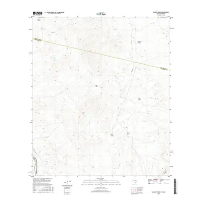
2016 Map of Soldier Spring
USGS Topo · Published 2016About this map
Soldier Spring and the surrounding drainage of Van Horn Cr dominate this section of West Texas near the international border. In this 2016 survey, the arid landscape is defined by its water management and geographic barriers, where features like White Tank and Painted Spring provided essential resources for cattle ranching. The map traces the county line between Jeff Davis Co and Presidio Co, a boundary that cuts across the high terrain of Chalk Mtn and Chalk Gap.
Find a feature on this map
19 named features on this map. Tap any name to fly to it.
Don’t see what you’re looking for? This feature index may not catch every label — zoom into the map to look around manually.
Map Details
Editions of this 2016 Soldier Spring Map
This is the sole edition of this map. No revisions or reprints were ever made.
Other maps of this area

1892 · Chispa
USGS Topo · 1:125,000

1895 · Chispa
USGS Topo · 1:125,000

1896 · San Carlos
USGS Topo · 1:125,000

1897 · Chispa
USGS Topo · 1:125,000

1959 · Marfa
USGS Topo · 1:250,000

1965 · Marfa
USGS Topo · 1:250,000
1972 · Mesquite Spring
USGS Topo · 1:24,000
1972 · Soldier Spring
USGS Topo · 1:24,000

1972 · Chispa
USGS Topo · 1:24,000
1972 · Ninetysix Ranch
USGS Topo · 1:24,000