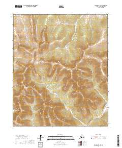
2017 Map of Solomon D-3 NW
USGS Topo · Published 2017About this map
Mt Wick rises as the primary topographic landmark within this interior Alaskan quadrangle near the Fish River. This 2017 survey documents a high-altitude landscape defined by the Melsing Creek Divide, where numerous drainage systems originate. The terrain is characterized by a dense network of watercourses, including Glacier Cr and Slate Cr, flowing through deep glacial valleys. The absence of roads or structures highlights the wilderness character of this area in the Nome Census Area, where human presence is primarily marked by the legacy of geographical naming along gold-bearing prospects such as Ready Bullion Cr and California Cr. These labels reflect the region's mining history, even in the absence of active industrial sites shown on this specific sheet.
Find a feature on this map
15 named features on this map. Tap any name to fly to it.
Don’t see what you’re looking for? This feature index may not catch every label — zoom into the map to look around manually.
Map Details
Editions of this 2017 Solomon D-3 NW Map
This is the sole edition of this map. No revisions or reprints were ever made.
Other maps of this area

1950 · Bendeleben A-4
USGS Topo · 1:63,360

1950 · Bendeleben A-3
USGS Topo · 1:63,360

1950 · Bendeleben
USGS Topo · 1:250,000

1950 · Solomon D-3
USGS Topo · 1:63,360

1950 · Solomon
USGS Topo · 1:250,000

1950 · Solomon D-4
USGS Topo · 1:63,360

1951 · Bendeleben
USGS Topo · 1:250,000

1951 · Solomon
USGS Topo · 1:250,000

1964 · Bendeleben
USGS Topo · 1:250,000

1970 · Bendeleben A-4
USGS Topo · 1:63,360