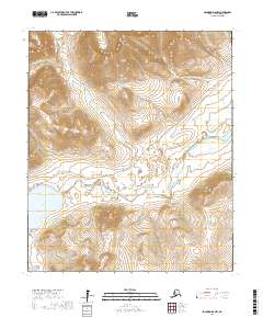
2017 Map of Solomon D-6 NW
USGS Topo · Published 2017About this map
Salmon Lake sits at the southwestern base of the Kigluaik Mountains, marking a significant geographical anchor in this portion of the Seward Peninsula. The landscape is defined by the drainage systems of the Pilgrim River and its numerous tributaries, including Crater Cr, Rock Cr, and Slate Cr. This 2017 survey reflects the enduring path of the Kougarok Road/Nome-Taylor Highway, a vital overland route that winds through the mountainous terrain and across the river plains.
Find a feature on this map
18 named features on this map. Tap any name to fly to it.
Don’t see what you’re looking for? This feature index may not catch every label — zoom into the map to look around manually.
Map Details
Editions of this 2017 Solomon D-6 NW Map
This is the sole edition of this map. No revisions or reprints were ever made.
Other maps of this area

1950 · Bendeleben A-6
USGS Topo · 1:63,360

1950 · Nome
USGS Topo · 1:250,000

1950 · Teller
USGS Topo · 1:250,000

1950 · Bendeleben
USGS Topo · 1:250,000

1950 · Solomon
USGS Topo · 1:250,000

1950 · Solomon D-6
USGS Topo · 1:63,360

1950 · Nome D-1
USGS Topo · 1:63,360

1950 · Teller A-1
USGS Topo · 1:63,360

1951 · Bendeleben
USGS Topo · 1:250,000

1951 · Nome
USGS Topo · 1:250,000