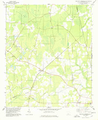
1978 Map of Solomons Crossroads
USGS Topo · Published 1978About this map
Solomons Crossroads serves as a central landmark in this 1970s landscape of the South Carolina Lowcountry, where the boundary between Allendale and Hampton counties is noted as an indefinite boundary. The map reveals a rural community structured around small crossroads and an extensive network of country churches, including Thompson Chapel, Clifton Ch, and Beech Branch Ch. The terrain is defined by low-lying wetlands such as Levy Bay and Hog Pen Bay, which contrast with the slightly higher ground of Blood Hill. Transport and commerce are evidenced by the Southern railroad line passing through Valentine and the proximity of the Groton Plantation Airport. The inclusion of numerous cemeteries and a Lookout Tower provides specific points of interest for those tracing family history or examining local land use patterns during this era of agricultural and timber activity.
Find a feature on this map
27 named features on this map. Tap any name to fly to it.
Don’t see what you’re looking for? This feature index may not catch every label — zoom into the map to look around manually.
Map Details
Editions of this 1978 Solomons Crossroads Map
This is the sole edition of this map. No revisions or reprints were ever made.
Other maps of this area

1918 · Varnville
USGS Topo · 1:62,500

1919 · Pineland
USGS Topo · 1:62,500

1919 · Shirley
USGS Topo · 1:62,500

1920 · Peeples
USGS Topo · 1:62,500

1943 · Pineland
USGS Topo · 1:62,500

1943 · Peeples
USGS Topo · 1:62,500

1943 · Shirley
USGS Topo · 1:62,500

1944 · Varnville
USGS Topo · 1:62,500

1947 · Savannah
USGS Topo · 1:250,000

1948 · Savannah
USGS Topo · 1:250,000