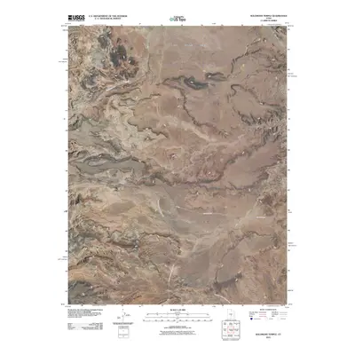
2010 Map of Solomons Temple
USGS Topo · Published 2010About this map
Solomons Temple stands as a prominent landmark in this high desert landscape within Sevier County, marking a terrain defined by extensive mesas and seasonal watercourses. The 2010 survey illustrates a sparsely developed region where the Last Chance Desert meets the northern reaches of Canyon Lands National Park. This map detail reveals the drainage patterns of the area, including the long paths of Temple Wash, Soloman Creek, and Middle Desert Wash, which carve through the elevated flats of Rock Springs Bench and Jones Bench. Transportation through this arid expanse is limited to remote corridors like County Rd-920 and F S 020, reflecting the area's isolation and its primary use for ranching or conservation at the start of the 21st century.
Find a feature on this map
12 named features on this map. Tap any name to fly to it.
Don’t see what you’re looking for? This feature index may not catch every label — zoom into the map to look around manually.
Map Details
Editions of this 2010 Solomons Temple Map
This is the sole edition of this map. No revisions or reprints were ever made.
Other maps of this area

1885 · Fish Lake
USGS Topo · 1:250,000

1896 · Fish Lake
USGS Topo · 1:250,000

1922 · Emery No.3
USGS Topo · 1:31,680

1952 · Notom 2 NW
USGS Topo · 1:24,000

1952 · Notom 2 NE
USGS Topo · 1:24,000

1952 · Torrey
USGS Topo · 1:62,500

1954 · Fruita
USGS Topo · 1:62,500
1954 · Notom 1 NW
USGS Topo · 1:24,000

1956 · Salina
USGS Topo · 1:250,000

1960 · Salina
USGS Topo · 1:250,000