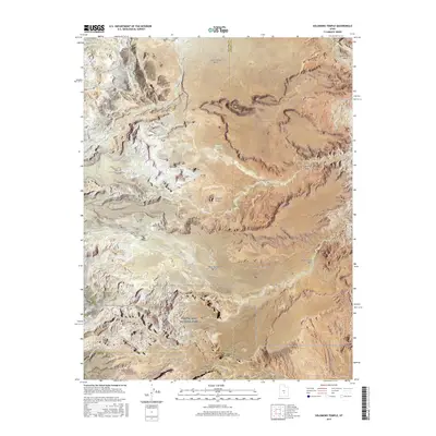
2017 Map of Solomons Temple
USGS Topo · Published 2017About this map
Capitol Reef National Park dominates the southern portion of this landscape, where the high desert terrain transitions into the protected geologic formations of the Waterpocket Fold region. The map reveals a network of seasonal watercourses and springs that define local geography, including the Last Chance Wash and Rock Springs Wash, which drain the expansive Last Chance Desert to the north. Named landmarks like Solomons Temple and Jones Bench provide essential orientation in this arid environment, where water sources such as Birch Spring and Jeffery Reservoir were historically vital for livestock and early ranching efforts. Remote routes like Baker Ranch Road and Cathedral Road trace the edges of the Middle Desert, illustrating the sparse but critical infrastructure connecting these remote canyons and plateaus along the borders of Sevier, Emery, and Wayne counties.
Find a feature on this map
26 named features on this map. Tap any name to fly to it.
Don’t see what you’re looking for? This feature index may not catch every label — zoom into the map to look around manually.
Map Details
Editions of this 2017 Solomons Temple Map
This is the sole edition of this map. No revisions or reprints were ever made.
Other maps of this area

1885 · Fish Lake
USGS Topo · 1:250,000

1896 · Fish Lake
USGS Topo · 1:250,000

1922 · Emery No.3
USGS Topo · 1:31,680

1952 · Notom 2 NW
USGS Topo · 1:24,000

1952 · Notom 2 NE
USGS Topo · 1:24,000

1952 · Torrey
USGS Topo · 1:62,500

1954 · Fruita
USGS Topo · 1:62,500
1954 · Notom 1 NW
USGS Topo · 1:24,000

1956 · Salina
USGS Topo · 1:250,000

1960 · Salina
USGS Topo · 1:250,000