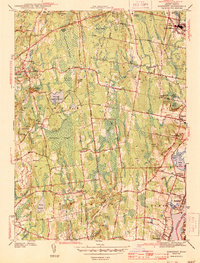
1943 Map of Somerset
USGS Topo · Published 1943About this map
Pottersville and Somerset anchor the southeastern corner of this Bristol County survey, where the Taunton River defines the landscape's edge. The 1942 fieldwork reveals a region of dense wetlands and interior drainage, notably the expansive Manwhague Swamp and Maple Swamp that separate the riverfront settlements from the western heights near Mount Terrydiddle. This era shows a transition between industrial and recreational land use, featuring the Taunton Dog Track in the north and the Somerset Pumping Sta along the Segreganset River. Researchers can trace old civic centers like Swansea Factory and Chestnut Tree Corner, which stand alongside family landmarks such as Great Meadow Hill. The New York New Haven and Hartford RR provides a critical transportation spine, connecting the riverside communities to the interior during the early 1940s.
Find a feature on this map
53 named features on this map. Tap any name to fly to it.
Don’t see what you’re looking for? This feature index may not catch every label — zoom into the map to look around manually.
Map Details
Editions of this 1943 Somerset Map
4 editions found
Other maps of this area

1885 · Taunton
USGS Topo · 1:62,500

1887 · Providence
USGS Topo · 1:62,500

1888 · Fall River
USGS Topo · 1:62,500

1888 · Taunton
USGS Topo · 1:62,500

1889 · Providence
USGS Topo · 1:62,500

1890 · Narragansett Bay
USGS Topo · 1:62,500

1892 · Narragansett Bay
USGS Topo · 1:62,500

1893 · Taunton
USGS Topo · 1:62,500

1893 · Fall River
USGS Topo · 1:62,500

1894 · Providence
USGS Topo · 1:62,500