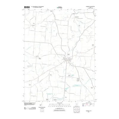
2010 Map of Somerset
USGS Topo · Published 2010About this map
Somerset serves as the central hub of this Perry County landscape, where a dense network of township roads radiates outward to smaller settlements like New Reading and Ziontown. The map reveals a high concentration of burial grounds, making it an essential resource for tracing local family history. Key sites include the New Saint Josephs Priory Cemetery and Old Saint Josephs Priory Cemetery near Lake Saint Joseph, alongside several denominational grounds such as the Hopewell Methodist Episcopal Cemetery and Evangelical Lutheran Cemetery.
Find a feature on this map
89 named features on this map. Tap any name to fly to it.
Don’t see what you’re looking for? This feature index may not catch every label — zoom into the map to look around manually.
Map Details
Editions of this 2010 Somerset Map
This is the sole edition of this map. No revisions or reprints were ever made.
Other maps of this area

1907 · Logan
USGS Topo · 1:62,500

1909 · Thornville
USGS Topo · 1:62,500

1909 · Logan
USGS Topo · 1:62,500

1910 · Zanesville
USGS Topo · 1:62,500

1911 · New Lexington
USGS Topo · 1:62,500

1947 · Columbus
USGS Topo · 1:250,000

1961 · Columbus
USGS Topo · 1:250,000

1961 · Rushville
USGS Topo · 1:24,000
1961 · Thornville
USGS Topo · 1:24,000

1961 · New Lexington
USGS Topo · 1:24,000