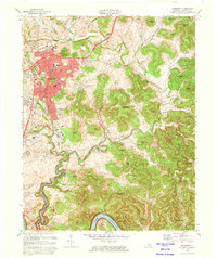
1973 Map of Somerset
USGS Topo · Published 1974About this map
Somerset serves as the focal point of this 1970s survey, showing the city's expansion south toward Ferguson and along the Southern railroad line. The landscape is defined by the transition from urban infrastructure, such as the University of Ky Community Col and St Mildreds Sch, to the deeply dissected terrain of the Cumberland River valley. To the south, the rising waters of Lake Cumberland have reached Antioch Bend, where the map includes underwater contours to 760 feet. Local genealogy is well-preserved through numerous family-named landmarks and rural institutions like Clay Hill Ch, Sulphur Springs Cem, and the high-elevation Potato Knob. This era captures the region's mid-century modernization, evidenced by the Somerset-Pulaski County Airport and the Bolton Airfield alongside traditional farm-to-market settlements like Ruth and Elihu.
Find a feature on this map
92 named features on this map. Tap any name to fly to it.
Don’t see what you’re looking for? This feature index may not catch every label — zoom into the map to look around manually.
Map Details
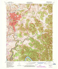
Editions of this 1973 Somerset Map
2 editions found
Other maps of this area

1890 · Williamsburg
USGS Topo · 1:125,000

1893 · London
USGS Topo · 1:125,000

1894 · Williamsburg
USGS Topo · 1:125,000

1897 · London
USGS Topo · 1:125,000

1932 · Burnside
USGS Topo · 1:62,500

1935 · Somerset
USGS Topo · 1:62,500

1952 · Hail
USGS Topo · 1:24,000

1952 · Dykes
USGS Topo · 1:24,000

1952 · Shopville
USGS Topo · 1:24,000

1953 · Frazer
USGS Topo · 1:24,000