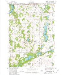
1974 Map of Somerset South
USGS Topo · Published 1977About this map
The Apple River flows through the town of Somerset, where local infrastructure including a Water Tank and High Sch sits near the Soo Line tracks. This mid-1970s landscape shows a transition between the established village centers and the developing recreational areas of St. Croix County. To the south, the village of Burkhardt is situated near the Chicago and North Western rail line and the extensive Willow River State Park, which encompasses Little Falls Lake and Mounds Pond.
Find a feature on this map
58 named features on this map. Tap any name to fly to it.
Don’t see what you’re looking for? This feature index may not catch every label — zoom into the map to look around manually.
Map Details
Editions of this 1974 Somerset South Map
This is the sole edition of this map. No revisions or reprints were ever made.
Other maps of this area

1946 · Hudson
USGS Topo · 1:62,500

1946 · River Falls
USGS Topo · 1:62,500

1948 · New Richmond
USGS Topo · 1:62,500

1948 · Stillwater
USGS Topo · 1:62,500

1949 · New Richmond
USGS Topo · 1:62,500

1949 · River Falls
USGS Topo · 1:62,500

1949 · Hudson
USGS Topo · 1:62,500

1949 · Stillwater
USGS Topo · 1:62,500

1949 · Hudson
USGS Topo · 1:24,000

1950 · Hudson
USGS Topo · 1:24,000