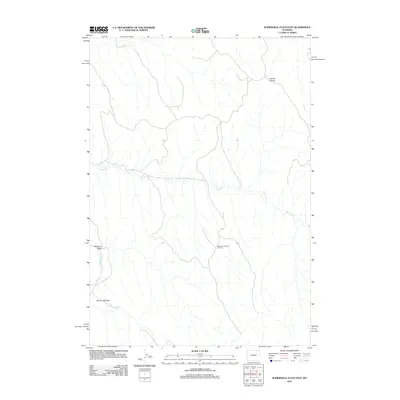
2012 Map of Somerville Flats East
USGS Topo · Published 2012About this map
Somerville Flats and the surrounding drainage of the Powder River define this stretch of Campbell County, Wyoming. The landscape is characterized by its energy production and high ground, most notably at the Barber Creek West Oil Field and the Kinney Divide that separates local watersheds. The winding course of Barber Cr moves across the terrain, illustrating the complex hydrology of the high plains. While largely unpopulated by major towns, the area is etched with the markers of resource extraction and seasonal water flow, such as Williams Draw. This topography provides a record of land use where industrial oil exploration meets the traditional rangeland of Northeast Wyoming.
Find a feature on this map
7 named features on this map. Tap any name to fly to it.
Don’t see what you’re looking for? This feature index may not catch every label — zoom into the map to look around manually.
Map Details
Editions of this 2012 Somerville Flats East Map
This is the sole edition of this map. No revisions or reprints were ever made.
Other maps of this area

1954 · Gillette
USGS Topo · 1:250,000

1955 · Sheridan
USGS Topo · 1:250,000

1955 · Gillette
USGS Topo · 1:250,000

1958 · Gillette
USGS Topo · 1:250,000

1958 · Sheridan
USGS Topo · 1:250,000

1962 · Gillette
USGS Topo · 1:250,000

1962 · Sheridan
USGS Topo · 1:250,000
1971 · Morgan Draw
USGS Topo · 1:24,000

1972 · Mitchell Draw
USGS Topo · 1:24,000
1972 · Carr Draw
USGS Topo · 1:24,000