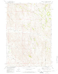
1972 Map of Somerville Flats East
USGS Topo · Published 1975About this map
The Powder River carves the southwestern corner of this landscape, where the wide Somerville Flats meet a network of draws and seasonal drainages. During the early 1970s, this portion of the Powder River Basin was defined by energy exploration and ranching infrastructure. The West Barber Creek Oil Field occupies the central hills, evidenced by numerous Oil Wells and a Jeep Trail system that connects remote drilling sites across the breaks.
Find a feature on this map
20 named features on this map. Tap any name to fly to it.
Don’t see what you’re looking for? This feature index may not catch every label — zoom into the map to look around manually.
Map Details
Editions of this 1972 Somerville Flats East Map
This is the sole edition of this map. No revisions or reprints were ever made.
Other maps of this area

1954 · Gillette
USGS Topo · 1:250,000

1955 · Sheridan
USGS Topo · 1:250,000

1955 · Gillette
USGS Topo · 1:250,000

1958 · Gillette
USGS Topo · 1:250,000

1958 · Sheridan
USGS Topo · 1:250,000

1962 · Gillette
USGS Topo · 1:250,000

1962 · Sheridan
USGS Topo · 1:250,000
1971 · Morgan Draw
USGS Topo · 1:24,000

1972 · Mitchell Draw
USGS Topo · 1:24,000
1972 · Carr Draw
USGS Topo · 1:24,000