
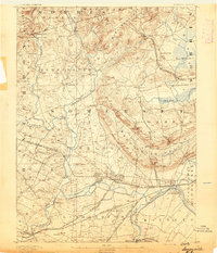
1891 Map of Somerville
USGS Topo · Published 1891About this map
Somerville stands as the central hub of this late nineteenth-century landscape, situated at a critical convergence of the Central Railroad of New Jersey and the Raritan River. The industrial and agricultural character of the era is evident in the engineered Water Power Cos Raceway near Milltown and the sprawling rail networks of the Philadelphia and Reading Railroad and Lehigh Valley Railroad that crisscross the southern terrain. To the north, the topographic relief of Mine Mountain and the Watchung Range shapes the distribution of smaller villages such as Pluckamin and Peapack.
Find a feature on this map
88 named features on this map. Tap any name to fly to it.
Don’t see what you’re looking for? This feature index may not catch every label — zoom into the map to look around manually.
Map Details
Editions of this 1891 Somerville Map
2 editions found
Other maps of this area

1888 · Plainfield
USGS Topo · 1:62,500

1888 · Morristown
USGS Topo · 1:62,500

1888 · Hackettstown
USGS Topo · 1:62,500

1888 · New Brunswick
USGS Topo · 1:62,500

1888 · Princeton
USGS Topo · 1:62,500

1888 · Lake Hopatcong
USGS Topo · 1:62,500

1890 · High Bridge
USGS Topo · 1:62,500

1890 · Lambertville
USGS Topo · 1:62,500

1891 · Lambertville
USGS Topo · 1:62,500

1893 · New Brunswick
USGS Topo · 1:62,500
Featured Places
- Franklin Township, NJ
- Piscataway Township, NJ
- Bridgewater Township, NJ
- Hillsborough Township, NJ
- Readington Township, NJ