
1893 Map of Somerville
USGS Topo · Published 1893About this map
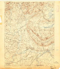
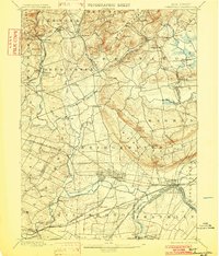
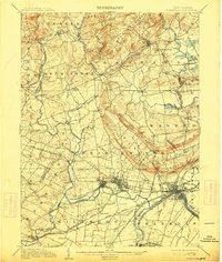
Somerville and the surrounding Somerset County landscape are defined by a complex network of waterways and early industrial infrastructure at the close of the nineteenth century. The confluence of the Raritan River and its branches dictates the layout of the region, supported by engineering works like the Water Power Cos Raceway near Raritan. This era shows a dense web of transportation, where the Central Railroad of New Jersey and the Lehigh Valley Railroad intersect at key hubs like Bound Brook. Natural landmarks such as Allimatona Falls and Chimney Rock provide geographical anchors among the many established villages. Smaller settlements like Greater Cross Roads and Pluckamin represent the rural character of the uplands before modern suburban expansion, while the presence of locations like North Branch Depot highlights the critical role of the rail-to-village economy.
Find a feature on this map
88 named features on this map. Tap any name to fly to it.
Don’t see what you’re looking for? This feature index may not catch every label — zoom into the map to look around manually.
Map Details
Editions of this 1893 Somerville Map
This is the sole edition of this map. No revisions or reprints were ever made.
Historical Maps of Madisonville Through Time
4 maps found
Featured Locations
- Piscataway Township, NJ
- Bridgewater Township, NJ
- Franklin Township, NJ
- Hillsborough Township, NJ
- Readington Township, NJ