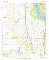
1970 Map of Sondheimer
USGS Topo · Published 1972About this map
The Mississippi River defines the eastern edge of this 1970s landscape, where the fertile alluvial plains of East Carroll and Madison Parishes support a network of small agricultural settlements. The Missouri Pacific railroad line acts as a central spine through the region, connecting Alsatia, Roosevelt, Sondheimer, and Enoka. This period in the Delta is marked by a deep-seated spiritual and community infrastructure, evidenced by numerous country churches such as Seventh Star Ch, New Zion Ch, and King Solomon Ch. A notable shift in land use is visible near Bull Bayou, where a Fish Farm and the Omega Landing Strip indicate diversifying rural industries. The terrain is crisscrossed by drainage and natural waterways, including Little Bayou Tensas and Talla Bena Bayou, which navigate the low-lying basins between established levee systems and settlements like Omega.
Find a feature on this map
33 named features on this map. Tap any name to fly to it.
Don’t see what you’re looking for? This feature index may not catch every label — zoom into the map to look around manually.
Map Details
Editions of this 1970 Sondheimer Map
This is the sole edition of this map. No revisions or reprints were ever made.
Other maps of this area

1909 · Millikens Bend
USGS Topo · 1:24,000

1909 · Tallulah
USGS Topo · 1:24,000

1935 · Waverly
USGS Topo · 1:62,500

1939 · Talla Bena
USGS Topo · 1:62,500

1939 · Alsatia
USGS Topo · 1:62,500

1955 · Jackson
USGS Topo · 1:250,000

1959 · Mitchiner
USGS Topo · 1:62,500

1961 · Jackson
USGS Topo · 1:250,000

1961 · Waverly
USGS Topo · 1:62,500

1962 · Jackson
USGS Topo · 1:250,000