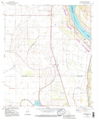
1994 Map of Sondheimer
USGS Topo · Published 1995About this map
Sondheimer and the surrounding agricultural bottomlands of the Mississippi River floodplain are documented here in the mid-1990s. The landscape is defined by its complex drainage network, where Tensas Bayou and Little Bayou wind through fertile tracts protected by a massive Levee system. This 1994 update reveals the modernization of the local economy, featuring a Fish Farm and the Omega Landing Strip, while maintaining deep ties to its community history through numerous rural congregations. Local genealogy is grounded in several churches, including Seventh Star Ch in Alsatia and King Solomon Ch further south. The proximity to the Mississippi River is ever-present, marked by features like the Salem Crevasse, illustrating the historical struggle and relationship between the delta settlements and the river's path.
Find a feature on this map
38 named features on this map. Tap any name to fly to it.
Don’t see what you’re looking for? This feature index may not catch every label — zoom into the map to look around manually.
Map Details
Editions of this 1994 Sondheimer Map
This is the sole edition of this map. No revisions or reprints were ever made.
Other maps of this area

1909 · Millikens Bend
USGS Topo · 1:24,000

1909 · Tallulah
USGS Topo · 1:24,000

1935 · Waverly
USGS Topo · 1:62,500

1939 · Talla Bena
USGS Topo · 1:62,500

1939 · Alsatia
USGS Topo · 1:62,500

1955 · Jackson
USGS Topo · 1:250,000

1959 · Mitchiner
USGS Topo · 1:62,500

1961 · Jackson
USGS Topo · 1:250,000

1961 · Waverly
USGS Topo · 1:62,500

1962 · Jackson
USGS Topo · 1:250,000