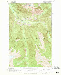
1963 Map of Sonny Boy Lakes
USGS Topo · Published 1970About this map
The North Fork and South Fork Cascade River converge within the Mt Baker National Forest, forming a deep drainage system that dictated early access to this part of the North Cascades. The 1963 field survey documents the Cascade Road and Sonny Boy Road as the primary corridors through the heavy timber, leading toward high-elevation landmarks like the Hidden Lake Lookout and the jagged Hidden Lake Peaks.
Find a feature on this map
29 named features on this map. Tap any name to fly to it.
Don’t see what you’re looking for? This feature index may not catch every label — zoom into the map to look around manually.
Map Details
Editions of this 1963 Sonny Boy Lakes Map
3 editions found
Other maps of this area

1899 · Glacier Peak
USGS Topo · 1:125,000

1901 · Glacier Peak
USGS Topo · 1:125,000

1953 · Marblemount
USGS Topo · 1:62,500

1955 · Concrete
USGS Topo · 1:250,000

1958 · Concrete
USGS Topo · 1:250,000

1962 · Concrete
USGS Topo · 1:250,000

1963 · Sonny Boy Lakes
USGS Topo · 1:24,000

1963 · Eldorado Peak
USGS Topo · 1:24,000
1963 · Forbidden Peak
USGS Topo · 1:24,000
1963 · Downey Mtn
USGS Topo · 1:24,000