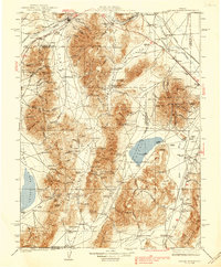
1939 Map of Sonoma Range
USGS Topo · Published 1939About this map
The Sonoma Range and Battle Mountain anchor this late 1930s survey of north-central Nevada, a landscape defined by its mining operations and deep-rooted ranching history. The transportation corridor follows the Humboldt River, where the Southern Pacific and Western Pacific railroads run parallel to the Victory Highway, serving settlements like Winnemucca, Golconda, and Valmy. The era's dependence on aviation is evident through the series of Airway Beacons positioned across the high terrain to guide early postal and commercial flights.
Find a feature on this map
143 named features on this map. Tap any name to fly to it.
Don’t see what you’re looking for? This feature index may not catch every label — zoom into the map to look around manually.
Map Details
Editions of this 1939 Sonoma Range Map
5 editions found

Other maps of this area

1882 · Paradise
USGS Topo · 1:250,000

1886 · Disaster
USGS Topo · 1:250,000

1893 · Paradise
USGS Topo · 1:250,000

1893 · Disaster
USGS Topo · 1:250,000

1908 · Carson Sink
USGS Topo · 1:250,000

1910 · Carson Sink
USGS Topo · 1:250,000

1926 · Roberts Mountains
USGS Topo · 1:250,000

1929 · Roberts Mountains
USGS Topo · 1:250,000

1931 · Lovelock
USGS Topo · 1:250,000

1932 · Sonoma Range
USGS Topo · 1:250,000