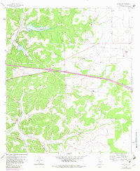
1964 Map of Sonora SE
USGS Topo · Published 1983About this map
Ranching estates and rural infrastructure define this portion of the Texas Edwards Plateau during the mid-1960s. The landscape is characterized by prominent family-named holdings such as Keene Ranch, Miers Ranch, and the Allison Ranch, which are interspersed among the winding topography of a large Draw. The map documents a transition in local transportation and utility networks, showing a significant Old Railroad Grade and several modern pipelines traversing the terrain. Flood control and water management are evident through markers like Site No 11 and Site No 12, which include specific spillway elevations. A Roadside Park along the primary highway suggests the area's role as a transit corridor for travelers crossing the Sutton County ranchlands.
Find a feature on this map
19 named features on this map. Tap any name to fly to it.
Don’t see what you’re looking for? This feature index may not catch every label — zoom into the map to look around manually.
Map Details
Editions of this 1964 Sonora SE Map
2 editions found
Other maps of this area

1893 · Rock Springs
USGS Topo · 1:125,000

1893 · Fort McKavett
USGS Topo · 1:125,000

1954 · Sonora
USGS Topo · 1:250,000

1958 · Sonora
USGS Topo · 1:250,000

1963 · Steen Lake
USGS Topo · 1:24,000

1963 · Buffalo Well NW
USGS Topo · 1:24,000

1963 · Buffalo Well SW
USGS Topo · 1:24,000

1964 · Sonora
USGS Topo · 1:24,000

1964 · Sonora SE
USGS Topo · 1:24,000

1964 · Sonora NE
USGS Topo · 1:24,000