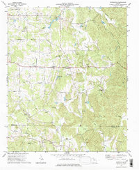
1972 Map of Sonoraville
USGS Topo · Published 1974About this map
Yarbroughs Mill and the surrounding agricultural landscape define this portion of Georgia in the early 1970s. The map illustrates a rural society organized around crossroads communities and numerous country sanctuaries, including Wesley Chapel, Bethlehem Ch, and Mt Pleasant Ch. Small settlements such as Sonoraville, Farmville, and Cash serve as local anchors, while the Gordon Co Bartow Co line marks the southern boundary of the quadrangle.
Find a feature on this map
43 named features on this map. Tap any name to fly to it.
Don’t see what you’re looking for? This feature index may not catch every label — zoom into the map to look around manually.
Map Details
Editions of this 1972 Sonoraville Map
2 editions found
Other maps of this area

1886 · Dalton
USGS Topo · 1:125,000

1890 · Cartersville
USGS Topo · 1:125,000

1891 · Cartersville
USGS Topo · 1:125,000

1892 · Dalton
USGS Topo · 1:125,000

1896 · Cartersville
USGS Topo · 1:125,000

1897 · Dalton
USGS Topo · 1:125,000

1914 · Talking Rock
USGS Topo · 1:62,500

1916 · Talking Rock
USGS Topo · 1:62,500

1941 · Adairsville
USGS Topo · 1:62,500

1944 · Adairsville
USGS Topo · 1:62,500