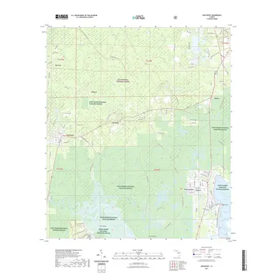
2021 Map of Sopchoppy
USGS Topo · Published 2021About this map
The Sopchoppy River meanders toward the Gulf of Mexico, anchoring a landscape where the wetlands of the Saint Marks National Wildlife Refuge and the Apalachicola National Forest converge. This 2021 survey details the intricate network of tidal creeks and lakes, including Otter Lake, Lake Ellen, and Levy Bay, that define the coastal character of Wakulla County. The settlement at Sopchoppy is central to the area, while the town of Panacea sits perched between Dickerson Bay and the wooded interior. Local genealogy is well-supported by the inclusion of Grimes Cem and Simmons Cem, alongside several named islands and points like Chesley Island and Simmons Point. Significant conservation land, including the Ochlockonee River State Park, dominates the southern portion of the map, illustrating the preservation of the river corridor as it approaches Apalachee Bay.
Find a feature on this map
103 named features on this map. Tap any name to fly to it.
Don’t see what you’re looking for? This feature index may not catch every label — zoom into the map to look around manually.
Map Details
Editions of this 2021 Sopchoppy Map
This is the sole edition of this map. No revisions or reprints were ever made.
Other maps of this area

1940 · Arran
USGS Topo · 1:62,500

1943 · Arran
USGS Topo · 1:62,500

1943 · St. Teresa Beach
USGS Topo · 1:24,000

1943 · Lighthouse Point
USGS Topo · 1:24,000

1945 · Bradwell Bay
USGS Topo · 1:31,680

1945 · Lighthouse Point
USGS Topo · 1:31,680

1945 · Mc Intyre
USGS Topo · 1:31,680

1945 · St Teresa
USGS Topo · 1:31,680

1945 · Sanborn
USGS Topo · 1:31,680

1949 · Apalachicola
USGS Topo · 1:250,000