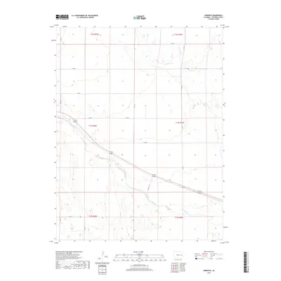
2019 Map of Sorrento
USGS Topo · Published 2019About this map
Sorrento sits as the primary settlement on this High Plains landscape in Cheyenne County, following the diagonal path of the highway and railroad corridor through eastern Colorado. The terrain is defined by the winding course of Big Sandy Cr and its tributaries, including Wild Horse Cr to the north. These drainage systems create subtle relief across the vast township divisions like t14s r50w and t13s r49w. A structured grid of section roads, such as Co Rd 12 and Co Rd R, provides access to the agricultural parcels that dominate the region. The map illustrates the 2019 configuration of this rural corridor, where historical land-use patterns of the Public Land Survey System remain the visible foundation of local geography.
Find a feature on this map
20 named features on this map. Tap any name to fly to it.
Don’t see what you’re looking for? This feature index may not catch every label — zoom into the map to look around manually.
Map Details
Editions of this 2019 Sorrento Map
This is the sole edition of this map. No revisions or reprints were ever made.
Other maps of this area

1891 · Arroyo
USGS Topo · 1:125,000

1891 · Kit Carson
USGS Topo · 1:125,000

1893 · Arroyo
USGS Topo · 1:125,000

1893 · Kit Carson
USGS Topo · 1:125,000

1954 · Lamar
USGS Topo · 1:250,000

1958 · Lamar
USGS Topo · 1:250,000

1978 · Galatea NE
USGS Topo · 1:24,000

1978 · Sanders Ranch
USGS Topo · 1:24,000
1978 · Wild Horse
USGS Topo · 1:24,000

1981 · Cheyenne Wells
USGS Topo · 1:100,000