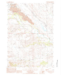
1984 Map of Sourdough Flats
USGS Topo · Published 1984About this map
The Belle Fourche River meanders across this Butte County landscape, defining a terrain of broad plateaus and deep drainage cuts. In the mid-1980s, the region shows a mix of traditional ranching geography and industrial extraction, evidenced by several Claypit and Clay workings concentrated near the riverbanks. Small rural hubs like Soper, Gray, and Kling serve as landmarks for local history, while the Chicago and North Western railroad corridor and the Wooden Pole Trans Line track the movement of resources through the plains.
Find a feature on this map
22 named features on this map. Tap any name to fly to it.
Don’t see what you’re looking for? This feature index may not catch every label — zoom into the map to look around manually.
Map Details
Editions of this 1984 Sourdough Flats Map
This is the sole edition of this map. No revisions or reprints were ever made.
Other maps of this area

1901 · Aladdin
USGS Topo · 1:125,000

1903 · Aladdin
USGS Topo · 1:125,000

1905 · Indian
USGS Topo · 1:62,500

1907 · Belle Fourche
USGS Topo · 1:125,000

1907 · Redwater
USGS Topo · 1:62,500

1953 · Rapid City
USGS Topo · 1:250,000

1954 · The Forks
USGS Topo · 1:24,000
1954 · Jolly
USGS Topo · 1:24,000
1954 · Belle Fourche
USGS Topo · 1:24,000

1954 · Gillette
USGS Topo · 1:250,000