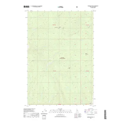
2020 Map of Sourdough Peak
USGS Topo · Published 2020About this map
Nez Perce National Forest defines the character of this Idaho County landscape, which is marked by a complex system of ridges and high mountain peaks. High points like Sourdough Peak and Baking Powder Mtn overlook a dense network of watercourses, including the headwaters of Johns Cr and the winding Frank Brown Cr. The terrain is characterized by steep elevation changes, with named landforms such as Blue Ridge, Bull Elk Ridge, and Bear Grass Ridge providing significant navigational landmarks. Transportation through this remote wilderness is sparse, centered primarily on the winding Sourdough Rd in the northeastern section. Small tributaries like Kentucky Cr and Twin Lakes Cr feed into the larger creek systems, illustrating the area's role as a vital watershed. This modern survey reflects the enduring wildness of the region, where land management boundaries like T28N R5E and T27N R5E delineate vast stretches of undeveloped forest land.
Find a feature on this map
30 named features on this map. Tap any name to fly to it.
Don’t see what you’re looking for? This feature index may not catch every label — zoom into the map to look around manually.
Map Details
Editions of this 2020 Sourdough Peak Map
This is the sole edition of this map. No revisions or reprints were ever made.
Other maps of this area

1931 · Buffalo Hump
USGS Topo · 1:125,000

1934 · Buffalo Hump
USGS Topo · 1:125,000

1956 · Elk City
USGS Topo · 1:250,000

1960 · Elk City
USGS Topo · 1:250,000

1962 · Golden
USGS Topo · 1:24,000

1963 · Sourdough Peak
USGS Topo · 1:24,000

1963 · Hanover Mtn.
USGS Topo · 1:24,000

1963 · Huddleson Bluff
USGS Topo · 1:24,000

1963 · Marble Butte
USGS Topo · 1:24,000
1963 · Hungry Ridge
USGS Topo · 1:24,000