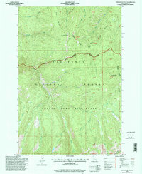
1995 Map of Sourdough Peak
USGS Topo · Published 1999About this map
Sourdough Peak and Baking Powder Mountain anchor this high-elevation landscape in north-central Idaho, where the intersection of multiple administrative boundaries defines the land use. The map captures a moment in the mid-1990s when the Frank Church River of No Return Wilderness, Gospel Hump Wilderness, and Nez Perce National Forest converge. This jurisdictional meeting point is reflected in the presence of four different ranger districts, including Santiam Ranger District and Clearwater Ranger District. The terrain is deeply incised by a complex drainage network featuring West Fork Twentymile Creek, Sourdough Creek, and Johns Creek. High-country water features like Moores Lake and Twin Lakes are situated among prominent landforms such as Bull Elk Ridge and Blue Ridge, illustrating the primitive character of this protected wilderness area before modern shifts in forest management.
Find a feature on this map
48 named features on this map. Tap any name to fly to it.
Don’t see what you’re looking for? This feature index may not catch every label — zoom into the map to look around manually.
Map Details
Editions of this 1995 Sourdough Peak Map
This is the sole edition of this map. No revisions or reprints were ever made.
Other maps of this area

1931 · Buffalo Hump
USGS Topo · 1:125,000

1934 · Buffalo Hump
USGS Topo · 1:125,000

1956 · Elk City
USGS Topo · 1:250,000

1960 · Elk City
USGS Topo · 1:250,000

1962 · Golden
USGS Topo · 1:24,000

1963 · Sourdough Peak
USGS Topo · 1:24,000

1963 · Hanover Mtn.
USGS Topo · 1:24,000

1963 · Huddleson Bluff
USGS Topo · 1:24,000

1963 · Marble Butte
USGS Topo · 1:24,000
1963 · Hungry Ridge
USGS Topo · 1:24,000