
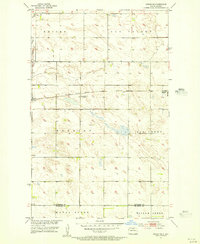
1954 Map of Souris SE
USGS Topo · Published 1956About this map
Stone Creek winds through a landscape of glacial depressions and prairie rises in this mid-century survey of the North Dakota borderlands. The map is defined by the rigid township and range system, where section lines divide the rural terrain into named districts such as Peabody, Pickering, Whitby, and Oakvalley. These designations often reflect the earliest organized civil townships, preserving the local political geography of the era. Settlement is sparse, characterized by isolated farmsteads connected by a grid of unimproved roads and light-duty routes.
Find a feature on this map
10 named features on this map. Tap any name to fly to it.
Don’t see what you’re looking for? This feature index may not catch every label — zoom into the map to look around manually.
Map Details
Editions of this 1954 Souris SE Map
This is the sole edition of this map. No revisions or reprints were ever made.
Other maps of this area

1949 · Kramer
USGS Topo · 1:24,000

1950 · Kramer
USGS Topo · 1:24,000

1954 · Souris SW
USGS Topo · 1:24,000

1954 · Souris
USGS Topo · 1:24,000

1954 · Gardena
USGS Topo · 1:24,000

1954 · Minot
USGS Topo · 1:250,000
1955 · Upham NE
USGS Topo · 1:24,000

1955 · Bottineau
USGS Topo · 1:24,000

1956 · Carbury
USGS Topo · 1:24,000

1956 · Lake McArthur
USGS Topo · 1:24,000