
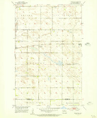
1954 Map of Souris SW
USGS Topo · Published 1955About this map
Boundary Creek meanders through the heart of this North Dakota landscape, a defining watercourse in a region characterized by its glacial prairie potholes and wetland depressions. Surveyed in the mid-1950s as part of the Department of the Interior program for the development of the Missouri River Basin, the map captures the organized township system of Eidsvold, Peabody, Starbuck, and Whitby. The terrain is marked by hundreds of small, scattered ponds and sloughs, illustrating the typical hydrology of the Souris River basin before modern drainage or extensive agricultural leveling. This period of mapping utilized aerial photographs taken in 1951, combined with plane-table surveys, providing a meticulous look at the section lines and small-scale relief of the Bottineau County countryside.
Find a feature on this map
9 named features on this map. Tap any name to fly to it.
Don’t see what you’re looking for? This feature index may not catch every label — zoom into the map to look around manually.
Map Details
Editions of this 1954 Souris SW Map
This is the sole edition of this map. No revisions or reprints were ever made.
Other maps of this area

1949 · Kramer
USGS Topo · 1:24,000

1950 · Kramer
USGS Topo · 1:24,000

1950 · Deep
USGS Topo · 1:24,000

1954 · Landa SE
USGS Topo · 1:24,000

1954 · Souris
USGS Topo · 1:24,000

1954 · Souris SE
USGS Topo · 1:24,000

1954 · Roth
USGS Topo · 1:24,000

1954 · Minot
USGS Topo · 1:250,000
1955 · Upham NE
USGS Topo · 1:24,000

1956 · Carbury
USGS Topo · 1:24,000