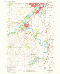
1971 Map of South Beloit
USGS Topo · Published 1973About this map
The Rock River dominates this Illinois-Wisconsin borderlands survey, winding southward from the industrial center of South Beloit through the river towns of Rockton and Roscoe. The landscape reflects a mix of heavy industry and recreation, where extensive Gravel Pits and quarries sit adjacent to large conservation areas like Macktown Forest Preserve and Hononegah Forest Preserve. The convergence of the Pecatonica River with the Rock River near Rockton creates a complex hydrologic network of creeks including Raccoon Creek and Dry Creek.
Find a feature on this map
83 named features on this map. Tap any name to fly to it.
Don’t see what you’re looking for? This feature index may not catch every label — zoom into the map to look around manually.
Map Details
Editions of this 1971 South Beloit Map
2 editions found
Other maps of this area

1891 · Janesville
USGS Topo · 1:62,500

1893 · Janesville
USGS Topo · 1:62,500

1893 · Shopiere
USGS Topo · 1:62,500

1918 · Rockford
USGS Topo · 1:62,500

1918 · Belvidere
USGS Topo · 1:62,500

1938 · Rockford
USGS Topo · 1:62,500

1944 · Belvidere
USGS Topo · 1:62,500

1949 · Rockford
USGS Topo · 1:24,000

1954 · Rockford
USGS Topo · 1:250,000

1955 · Rockford
USGS Topo · 1:250,000