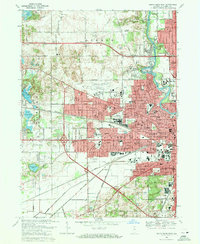
1969 Map of South Bend West
USGS Topo · Published 1971About this map
The St Joseph River defines the eastern edge of this late-1960s landscape, winding past the campus of St Marys College and Holy Cross College before entering the urban core of South Bend. The map documents a period of significant infrastructure development, most notably the intersection of the Indiana East-West Toll Road and the U. S. 20 Bypass, which surrounds the sprawling St Joseph County Airport (Bendix Field).
Find a feature on this map
77 named features on this map. Tap any name to fly to it.
Don’t see what you’re looking for? This feature index may not catch every label — zoom into the map to look around manually.
Map Details
Editions of this 1969 South Bend West Map
4 editions found
Other maps of this area

1927 · Niles
USGS Topo · 1:62,500

1930 · Niles
USGS Topo · 1:62,500

1943 · Niles
USGS Topo · 1:62,500

1945 · Cassopolis
USGS Topo · 1:62,500

1947 · Cassopolis
USGS Topo · 1:62,500

1953 · Chicago
USGS Topo · 1:250,000

1957 · Chicago
USGS Topo · 1:250,000

1958 · South Bend East
USGS Topo · 1:24,000

1958 · South Bend West
USGS Topo · 1:24,000

1958 · Lydick
USGS Topo · 1:24,000