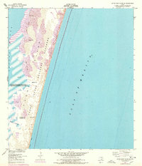
1951 Map of South Bird Island SE
USGS Topo · Published 1978About this map
Padre Island National Seashore dominates this coastal survey, revealing a dynamic landscape of shifting sand dunes and mudflats between the Gulf of Mexico and Laguna Madre. The map details a transition point on the barrier island, where the Kleberg Co and Kenedy Co boundary line crosses the shoreline near Boggy Slough. Geographically distinct landmarks like Green Hill, Dagger Hill, and Big Ball Hill provide fixed points among the ever-changing sands. The small settlement of Union is noted on the bay side, offering a rare point of human habitation in this maritime environment. This edition includes 1975 photorevisions, highlighting changes in the Shifting Sand Dunes and the shoreline of Little Shell, essential for understanding the natural evolution of the Texas coast during the mid-20th century.
Find a feature on this map
14 named features on this map. Tap any name to fly to it.
Don’t see what you’re looking for? This feature index may not catch every label — zoom into the map to look around manually.
Map Details
Editions of this 1951 South Bird Island SE Map
3 editions found
Other maps of this area

1950 · Corpus Christi
USGS Topo · 1:250,000

1951 · South Bird Island
USGS Topo · 1:24,000

1951 · South Bird Island SE
USGS Topo · 1:24,000

1951 · South Bird Island NW
USGS Topo · 1:24,000

1951 · Point Of Rocks
USGS Topo · 1:24,000

1951 · South Bird Island
USGS Topo · 1:62,500

1952 · Yarborough Pass
USGS Topo · 1:24,000
1955 · Potrero Cortado
USGS Topo · 1:62,500

1956 · Corpus Christi
USGS Topo · 1:250,000

1960 · Corpus Christi
USGS Topo · 1:250,000