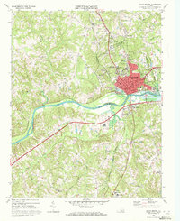
1969 Map of South Boston
USGS Topo · Published 1972About this map
South Boston serves as the industrial and civic heart of this Southside Virginia landscape, situated at a critical junction where the Dan River meets the John H Kerr Reservoir. The map illustrates a period of mid-century infrastructure expansion, evidenced by the Filtration Plant, Industrial Waste Pond, and the proximity of the Southern and Norfolk and Western railroads. Beyond the urban center, the terrain is dotted with small communities like Centerville and Loves Shop, alongside numerous local landmarks such as the Drive-in Theater and Halifax Community Hospital. Genealogists will find significant value in the documentation of several country churches and burial grounds, including the Oak Ridge Cemetery and Dan River Bethel Ch. The presence of the Washington Coleman Sch and Friend Sch reflects the local educational landscape during this era of Halifax County's history.
Find a feature on this map
57 named features on this map. Tap any name to fly to it.
Don’t see what you’re looking for? This feature index may not catch every label — zoom into the map to look around manually.
Map Details
Editions of this 1969 South Boston Map
Other maps of this area

1952 · Milton
USGS Topo · 1:62,500

1953 · South Boston
USGS Topo · 1:62,500

1953 · Greensboro
USGS Topo · 1:250,000

1954 · Greensboro
USGS Topo · 1:250,000

1954 · Halifax
USGS Topo · 1:62,500

1954 · Riceville
USGS Topo · 1:62,500

1956 · Milton
USGS Topo · 1:62,500

1957 · South Boston
USGS Topo · 1:62,500

1962 · Greensboro
USGS Topo · 1:250,000

1966 · Greensboro
USGS Topo · 1:250,000