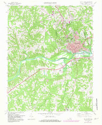
1969 Map of South Boston
USGS Topo · Published 1982About this map
The South Boston municipal area serves as the central hub of this 1969 survey, where the confluence of the Dan River and the rising waters of the John H Kerr Reservoir shape the local landscape. The map reveals a dense network of community life, anchored by landmarks such as the Halifax Community Hospital and educational centers like the Washington Coleman Sch. Rural life in Halifax County is characterized by numerous small settlements and religious centers, from the northern hamlets of Sinai and Centerville to the isolated Dan River Bethel Ch in the south.
Find a feature on this map
47 named features on this map. Tap any name to fly to it.
Don’t see what you’re looking for? This feature index may not catch every label — zoom into the map to look around manually.
Map Details
Editions of this 1969 South Boston Map
Other maps of this area

1952 · Milton
USGS Topo · 1:62,500

1953 · South Boston
USGS Topo · 1:62,500

1953 · Greensboro
USGS Topo · 1:250,000

1954 · Greensboro
USGS Topo · 1:250,000

1954 · Halifax
USGS Topo · 1:62,500

1954 · Riceville
USGS Topo · 1:62,500

1956 · Milton
USGS Topo · 1:62,500

1957 · South Boston
USGS Topo · 1:62,500

1962 · Greensboro
USGS Topo · 1:250,000

1966 · Greensboro
USGS Topo · 1:250,000