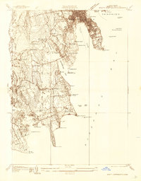
1936 Map of South Dartmouth
USGS Topo · Published 1936About this map
New Bedford and Fairhaven anchor this coastal survey, where the urban grid meets the finger-like peninsulas of Buzzards Bay. The military presence at Fort Rodman and the industrial-era infrastructure of the Almshouse and Sol-e-mar Hospital define the shoreline near Clark Point LH. Inland, the landscape transitions into a network of small family-named crossroads like Macombers Corner and Wilburita Corner, reflecting a rural economy still tied to the land, evidenced by a Cranberry Bog near Bakersville.
Find a feature on this map
59 named features on this map. Tap any name to fly to it.
Don’t see what you’re looking for? This feature index may not catch every label — zoom into the map to look around manually.
Map Details
Editions of this 1936 South Dartmouth Map
This is the sole edition of this map. No revisions or reprints were ever made.
Other maps of this area

1885 · New Bedford
USGS Topo · 1:62,500

1885 · Sakonnet
USGS Topo · 1:62,500

1887 · Gay Head
USGS Topo · 1:62,500

1888 · New Bedford
USGS Topo · 1:62,500

1888 · Fall River
USGS Topo · 1:62,500

1888 · Sakonnet
USGS Topo · 1:62,500

1889 · Gay Head
USGS Topo · 1:62,500

1893 · Gay Head
USGS Topo · 1:62,500

1893 · Sakonnet
USGS Topo · 1:62,500

1893 · Fall River
USGS Topo · 1:62,500