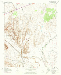
1954 Map of South Garcia
USGS Topo · Published 1973About this map
Laguna Indian Reservation (Antonio Sedillo Grant) dominates the central landscape of this New Mexico quadrangle, where the Atchison Topeka and Santa Fe railroad snakes through the valleys between prominent plateaus. The topography is defined by the massive elevation of Black Mesa and the distinct formation of Mesa Redonda to the west. Near the railroad line, the small settlement at South Garcia and the Antonio Sedillo Grant Headquarters provide evidence of early territorial management and ranching operations. The confluence of the Rio San Jose and the Rio Puerco near the boundary with the Isleta Pueblo Indian Reservation Grant highlights the critical water sources in an otherwise arid environment. Historic access is marked by the Caroncito School Road and scattered water points like Dipping Vat Spring and El Ojo Escondido, reflecting the land's pastoral and community history.
Find a feature on this map
18 named features on this map. Tap any name to fly to it.
Don’t see what you’re looking for? This feature index may not catch every label — zoom into the map to look around manually.
Map Details
Editions of this 1954 South Garcia Map
2 editions found

Other maps of this area

1883 · Mt. Taylor
USGS Topo · 1:250,000

1886 · Mt. Taylor
USGS Topo · 1:250,000

1888 · Bernalillo
USGS Topo · 1:125,000

1889 · Albuquerque
USGS Topo · 1:125,000

1892 · Mt. Taylor
USGS Topo · 1:250,000

1893 · Albuquerque
USGS Topo · 1:125,000

1899 · Mt. Taylor
USGS Topo · 1:250,000

1917 · Cerro Verde
USGS Topo · 1:125,000

1952 · Rio Puerco
USGS Topo · 1:24,000

1952 · Dalies NW
USGS Topo · 1:24,000