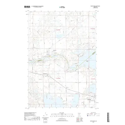
2019 Map of South Haven
USGS Topo · Published 2019About this map
Clearwater River winds through this central Minnesota landscape, defining the transition between the agricultural and lake-rich districts near the border of Stearns and Wright Counties. The settlement of South Haven stands as a primary focal point, while the northern village of Fairhaven sits near the river's path. This survey reveals a high density of rural cemeteries, including Fairhaven Cem and Concordia Cem, which offer significant value for genealogists tracing early families in the region. The map captures an intricate network of glacial lakes such as Lake Augusta, Clearwater Lake, and East Lake Sylvia, showing how local infrastructure like County Highway 45 and County Road 44 navigates the numerous wetlands and shorelines that characterize the township.
Find a feature on this map
67 named features on this map. Tap any name to fly to it.
Don’t see what you’re looking for? This feature index may not catch every label — zoom into the map to look around manually.
Map Details
Editions of this 2019 South Haven Map
This is the sole edition of this map. No revisions or reprints were ever made.
Other maps of this area

1951 · Annandale
USGS Topo · 1:62,500

1953 · Saint Cloud
USGS Topo · 1:250,000

1957 · Saint Cloud
USGS Topo · 1:250,000

1958 · Saint Cloud
USGS Topo · 1:250,000

1958 · Dassel
USGS Topo · 1:62,500

1958 · Cokato
USGS Topo · 1:62,500

1967 · Rockville
USGS Topo · 1:24,000

1967 · Kimball
USGS Topo · 1:24,000
1974 · St Augusta
USGS Topo · 1:24,000
1974 · Annandale
USGS Topo · 1:24,000